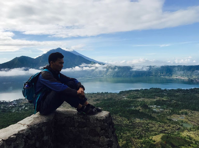
Mount Batur Trekking. A UNESCO geopark in Bali.

Volcanic geopark of Indonesia Bali
Batur 1,717 m above sea level

I was impressed for the first time to hike Mount Batur because I get information that it is one of two UNESCO Global Geoparks in Indonesia. Thanks to Youth Leadership Camp for Climate Change 2017. The journey of this experience is worth to try, especially if you are in Bali and seeking for alternative rather than just sandy beach. This journey is a description on how I enjoy sunrise from highland in Bali and various feature in this geopark..

First of all, Indonesia has two Global Geopark recognized by UNESCO. Besides mount Batur, Sewu mount that located in the area of three provinces in Java is recognized in 2015. Mount Batur recognized at 2012. However, there are plentiful geopark in Indonesia as the archipelago is full of ancient and active volcanoes due to its location on the zone of ring of fire. Geopark is unified area that rich of geological as well as cultural heritage that intended to promote awareness and economic well-being of people who live surround area through various effort, typically by tourism.

As a former student of mining engineering that learn geology as well, I am very keen to visit this geopark. Located at Kintamani sub district, 82 km from Ngurah Rai International Airport, Denpasar, Bali, Mount Batur is the easiest volcano to hike compare to mount Agung, or Bratan.

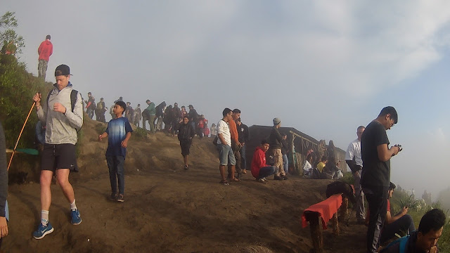
Our journey was started at 2pm. Our ambition is to see sunrise on the top of Batur. Using motorbike, it just takes two hours to the starting point of trekking. In starting point, we were not alone, there are estimated 500 hundreds people hike to the top of mountain. Majority are International tourist. All visitors have to pay entrance fee. For local, it is just 3k while international is 100k plus international tourist have to guided by professional while for local, it is optional. Paying guide tour is pretty expensive here. The price is 400k and limited for 4 people only. Of course foreign visitor pay so high compare to local. I just remember when I was in Montana, US, I pay 0 for hiking to Jumbo mountain. A high price even compared to developed country.
Volcano in Bali
Crowd on top of Batur
With high price, mount Batur is a worthwhile experience. Walking in the dawn around two until three hours, the scenery of sunrise is breath taking. In the dawn it is full of light bulb from house near lake Batur, the second biggest caldera lake in the world due to big explosion 29,300 years ago.

Batur Lake Kintamani
Light Bulb along Batur Lake

In the morning, it is so clear that we were walking in the cloud. On top, we might be still in the cloud. However wind change the location of cloud opening the beautiful scenery of other side of Mount Batur. In the middle of it, is Lake Batur, the ancient caldera of this volcano.

Top of Batur
Here on the top, human is not the only creature. Kintamani dogs and monkey are everywhere, waiting for the food from visitors. They exhibit a good attractions. Monkeys can go up to your shoulder if you put food on your head. They drinks and eat every meals. Instant noodle, coffee, milk, and bread, they eat them all. They are aggressive but friendly. As information, locals here believe that they are holy and special. For local, this monkey is a sign that Batur is in a good condition. If all monkey is going down, it means bad conditions is happening.

Monkey on top of Batur
Way go down was very cool. It is time to see the feature of the geopark. Down the peak, the black volcanic sand is a footprint of lava. It is important to note that, Batur is active volcano, it may erupt every time. It is very important to be aware for information from volcanology center. Black volcanic rocks is mafic igneous rock which has low silica content that mainly comprised of Olivine, Pyroxene, Amphibole, Biotite Mica, and the Plagioclase Feldspar minerals. A huge footprint of lava and lake Batur is sign that there were dreadful explosions of Batur.

Mafic igneous volcanic rock
Black volcanic sand of Batur
 Along the way go down, I also found red felsic rock, a volcanic rock that rich of silica content that mainly comprised of Potassic feldspar and alumunium. It indicates that Batur explode not once. Based on information from information board, mount Batur erupted 26 times from 1804 - 2000 and the most devastated one was in 1926.

Felsic Igneous rock
Felsic volcanic rock of Batur Explosion
Still on the way go down, the tour guide escorted us to the hotspot, an area that has a natural steam. Here the steam is out from the rocks like an outdoor sauna. Local believe that this spot is sacred, they sometimes pray in here. This steam is a sign that we are very close from magma. The temperature of magma heat underground water and create steam. Some tourist also bury egg near the location for cool way of cooking.

Hotsteam of Batur
Natural steam of Batur
Tour guide also brought us to cave. This cave is rich of legend story. You better hear from tour guide directly. This place is also sacred for local and used for many rituals.

Cave in Batur
On slope of Batur, there are plentiful of farm field. Locals use the fertile soil of mount Batur to plant various vegetables. I feel way go down is longer than way go up. Might be because I was so excited during trekking to the top. Near from starting point, you may also find hot spring that turn to become artificial pool. They have a good restaurant as well. Here, you may swim next to water of lake Batur. The entrance fee for local is 60k and for international 100k.

Hot spring swimming pool near from starting point of Batur trekking
This journey is so cool. I have heard many times, and I would like to tell you that there are a scientific reason why spending on experience is much worth than buying goods. If you are young, you are still strong enough to hike or dive. Hike as high as you can, and dive as deep as you can. Thank you so much for my adventure-mate, Nisa and Annie. Let's go to next top.

Let's explore more
Strong girl
Backpacker to Batur Kintamani, Bali
No caption


Comments

Popular posts from this blog

IELTS Academic Writing Task 1 - Map

Naik pete-pete apa ke Mall Panakkukang?

IELTS Writing Task 1 - Process